‘DEF CON 1′ Tornado Outbreak Looms for Texas, Oklahoma and Kansas
What is DEF CON?
I was first introduced to the term 'DEF CON' (defense condition) by the movie War Games. On a scale of 1 to 5, DEF CON 1 is the most severe...the most dangerous.
DEF CON is not a term used in weather forecasting, but meteorologists at the Storm Prediction Center in Norman, Oklahoma have released their latest outlook for severe weather today and tonight, and it is the most severe, the most dangerous on their scale of 1 to 5.
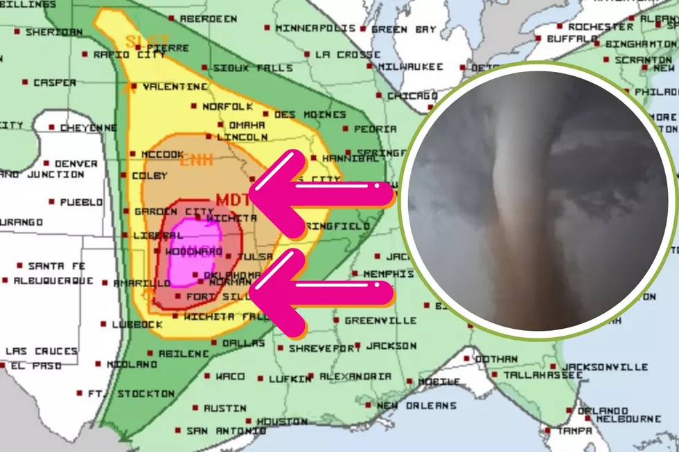
You Don't Want to See Pink on a Weather Map
The pink color in parts of Oklahoma and Kansas is a rarity. This is as close as you can get to a Tornado Warning before the storms have even formed.
This is an extremely dangerous situation for anyone who lives in Dallas and Wichita Falls northward to Wichita, Kansas. The biggest threat will fall to those living within the brown to red to pink shaded regions such as Oklahoma City, Lawton, and Wichita.
The National Weather Service in Norman has issued the following advisory:
"A significant severe weather outbreak...is expected to impact Oklahoma and potentially western North Texas this afternoon and through the evening and result in strong, long-lived tornadoes, very large to giant hail, two to four inches in diameter, and damaging wind gusts 80 mph or more."
"Explosive thunderstorm development is likely to begin mid-afternoon to early evening over western Oklahoma, with some potential for an initial round of tornadic supercells to affect the I-35 corridor near rush hour."
"The second round of severe thunderstorms appears to move into north and central Oklahoma early evening into the overnight hours. Storms are forecast to continue tonight as they progress eastward and exit our forecast area early Tuesday morning. The tornado risk will increase late evening and into the overnight hours."
Tornado Risk
Strong, long-lived tornadoes mean that EF2 or stronger (111+ mph) twisters are almost guaranteed to happen, and some of those could stay on the ground for a long while.
Anyone living within the pink hatched area has a 30% chance of experiencing an EF2 or stronger tornado within 25 miles of their home. It's very rare for meteorologists to have that kind of confidence in a tornado or severe weather outbreak, but that just gives you an indication of how dangerous this storm system is expected to be.
Texas Impact
The extreme northern tier of Texas from Wichita Falls to Denton to Texarkana, along with the eastern Texas Panhandle will need to closely monitor the weather today and tonight. Even though the highest potential for severe weather lies in Oklahoma and Kansas, forecast models are not always 100% accurate.
Once Monday passes, Texas won't have to wait long for the next hazardous weather situation. Much of north-central, east, and northeast Texas is marked for severe weather on Wednesday...
...with another go-round of severe weather anticipated on Thursday.
BEAUTIFUL: These Are the Best Scenic Drives in Texas
Gallery Credit: Stacker
More From 106.3 The Buzz


