Latest Wichita Falls Evacuation Details + Flood Maps [VIDEO]
UPDATE: MAY 24 6:41 PM
UPDATE: MAY 24 10:35 AM
Wichita Falls Mayor Glenn Barham has announced that the staff at the Emergency Operations Center is working on a reentry plan for all evacuated residents. Power should be returned to the Tanglewood Neighborhood later this afternoon. Also, later this afternoon residents are expected to be able to return to their homes.
PLEASE NOTE: Do not drive into water covering a roadway to return to your home. Tanglewood's return will be monitored by the Wichita Falls Police Department to ensure safety and security. No one will be allowed to enter water crossing a roadway. As well, there are roadways in the county that are covered with deep water. Do not cross these roadways for any reason. Thank you for your patience and understanding.
More updates coming soon and we should know by 1:00 pm about several issues. We will update this page as soon as the city sends out new notices about returning to homes.
UPDATE May 23 6:00 pm
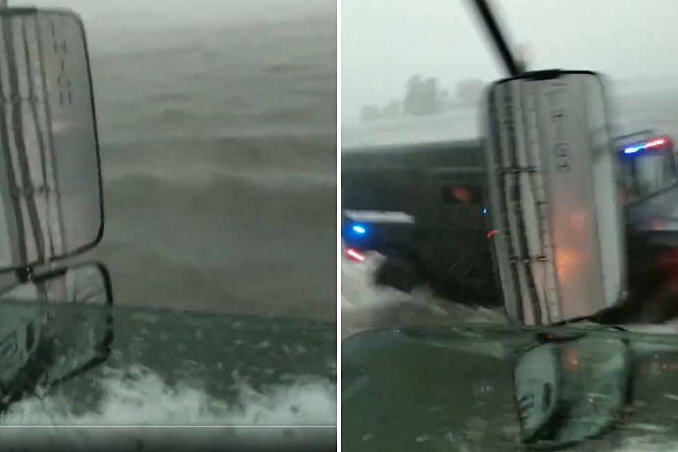
The City of Wichita Falls and Wichita County have issued an evacuation order for residents living along the Wichita River within one-half mile of either side of the river. The National Weather Service as calling this an “historic” flood event.
A map depicting the areas that are expected to flood can be found here or on the City Website at wichitafallstx.gov. Anyone living in the red area of the map is advised to evacuate.
Flood waters are continuing to rise and backwater from the Big Wichita River is now impacting ditches and culverts well away from the immediate flood danger areas of Tanglewood, Wranglers Retreat, Horseshoe Bend and East Side areas. Please check back frequently for updates on evacuation plans, road closures and more.
Area Emergency Management personnel have been working closely with the National Weather Service (NWS) to determine the severity of the threat of flooding in the City and County. The NWS feels that the likelihood of severe flooding is possible beginning late Saturday night (May 23rd) and running through early next week. For questions please contact the Emergency Operations Center at 761-7909.
From the Wichita Falls Police Department:
All residents in Wichita Falls please be advised that the only City representatives who will go door-to-door for mandatory evacuations are uniformed Wichita Falls Police Officers or Fire Fighters. Anyone else appearing at a home or apartment complex advising residents to evacuate are not operating with the authority of the Emergency Operation Center and may be planning on committing an illegal act such as a burglary when a resident leaves the property. Please contact local Law Enforcement and report this person.
Evacuations
The Red Cross has set up shelter facilities at the Hirschi High School Gym, 3106 Borton. Antioch Baptist Church, 601 Bonner, located on the East Side of Wichita Falls is also preparing their facility to operate as a shelter.
As of Friday morning, estimates for evacuations are 153 homes in the Tanglewood neighborhood (with their power cut to prevent the chance of electrical fires) and 35 homes on the East Side, their power was not shut off.
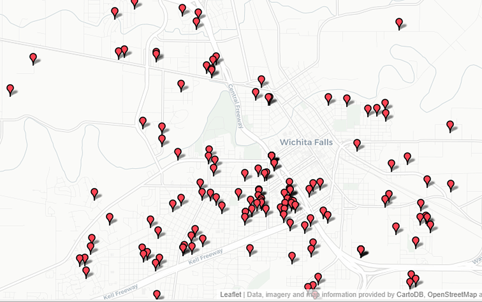
Flood Maps
The following maps indicate areas of the City of Wichita Falls that were flooded in 2007. These are the areas expected to be flooded during the current May 2015 flood event. The maps indicate the areas that were flooded and the homes that were flooded.
Click the links to view the maps:
What to Expect
The Loop 11 river gauge, one of the gauges measuring the Wichita River, indicates that the river is on the rise but slow, 1/10 of a foot rise every hour. The river, at this time, is estimated to crest at 21.3 feet at 1:00 am Saturday morning. This could change as predictions are updated.
6-8 inches of rain is forecast for Friday and Saturday and could affect flood predictions. When the flood waters arrive residents are urged NOT to enter the water on foot, by vehicle or any other method. Flood waters are unpredictable, dangerous and pose a significant health hazard. Never attempt to drive across any flooded roadways.
The City is still pumping out the Duncan Channel on the East Side using two pumps that empty the channel water into the Wichita River. This effort is credited with saving several homes from flooding.
Evacuation Preparations
1. Gathering all medications.
2. Making plans for housing all pets (remember their medication and special diet foods).
3. Preparing the contents of your home: raising items, electronics, hazardous materials (paint, solvents, cleaning supplies, important papers…etc.) to a level well above the level the water may have reached in 2007.
4. Disconnecting electrical appliances.
5. Securing a copy of your insurance policies and other important documents.
There will also be a Point of Distribution Center opening on Thursday in the old Brookshire’s grocery store building, on the corner of Loop 11 and Seymour Highway. Those affected by the flood can receive assistance from various agencies, essential items, immunizations and refreshments.
Pets
Residents with pets and no place to keep them can contact Animal Services at 940-447-0343 for assistance. The Wichita County Humane Society is also taking in pets.
Current Road Closures:
Roadways Closed:
IH 35 (Cooke Co) service road is closed at the Red River and at Valley View.
IH 44(Wichita Co.) service road is closed at the Wichita River.
FM 1740 (Clay & Wichita Co.)closed from reference marker 492 to 494. 12” water over road.
Water over the roadways:
FM 369 (Wichita Co.)- water over road at Haws Rd.
FM 367 (Wichita Co.)- water over road between Loop 11 and FM 1634
SH 101 (Montague Co.)
Sandbags Available Free of Cost
Locations for sand / sandbag pickup are: Eskimo Hut on Seymour Highway and Tanglewood Drive; the City of Wichita Falls Communications Center at 710 Flood Street; at 1100 Webster at the County Precinct 1 yard. Additional locations will be set up on Saturday. We will provide you with that information as it becomes available.
Questions
Residents with questions should contact the Emergency Operations Center at 761-7909
Volunteer
Residents who would like to volunteer their time or donate goods for flood assistance can also use the United Way 2-1-1 system. Call 2-1-1, choose a language and then “Option 1.”
More From 106.3 The Buzz


![Best Swimming Holes in Texas [PHOTOS]](http://townsquare.media/site/142/files/2019/05/Hamilton-Pool-Corey-Van-Zandt-10.jpg?w=980&q=75)
![Best Halloween Pumpkin Patches in Wichita Falls [2018]](http://townsquare.media/site/153/files/2012/09/pumpkin.jpg?w=980&q=75)

